Uploading your own data layers requires an Enterprise subscription. To learn more about Enterprise access and capabilities, fill out this quick form and an Acres representative will be in touch to see how we can support your business!
Acres provides thousands of data overlays in the Layer Library, but users may also upload their own data with a simple drag and drop system. Private layers allow you to bring your own data into Acres and instantly visualize it on the map.
Steps:
- You have two options to upload your layer:
- Open the Layers tab on the left hand menu and click the green Upload button at the top of the Layers menu
- Access the Tool Bar at the top of your map and click the Upload icon (an arrow point up) on the far right.
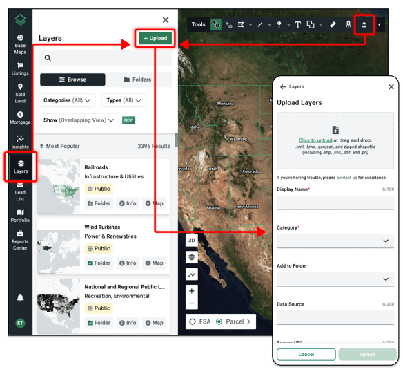
- Drag and drop your file into the upload box. Our supported file types for drag and drop upload include: kml, .kmx, .geojson, and zipped shapefile (including .shp, .shx, .dbf, and .prj)
- Fill out the following information:
- Display Name (required)
- Category (required) — such as Environmental or Recreation
- Add to Folder
- Data Source
- Source URL
- Notes
- Click the green Upload button on the bottom right.
- Wait for a successful upload. Acres will notify you of a successful file upload with a brief message. Typically, it will take up to 5 minutes to upload your desired file, depending on its size.
- Refresh your screen to find your new data layer in Acres!